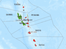
Cyclone Pam in Vanuatu (Archive)
Digital volunteers from the Digital Humanitarian Network have been working around the clock to provide targeted support to the residents of Vanuatu, and the humanitarian teams who are providing on-site support. The DHN was activated by the UN Office for the Coordination of Humanitarian Affairs (http://www.unocha.org/). The Humanitarian OpenStreetMap Team (http://hot.openstreetmap.org/), Humanity Road (http://humanityroad.org/), PeaceGeeks (http://peacegeeks.org/), the Standby Task Force (http://blog.standbytaskforce.com/) and GISCorps (http://www.giscorps.org/) quickly formed inter-disciplinary teams to meet the urgent information needs of those affected by this major event. Here are some of the highlights of the work they have been doing:
- Creating digital basemaps for use by rapid responders and other organizations - the Humanitarian OpenStreetMap team are responding quickly, looking for imagery and digitizing to add / revise the map to include the airports, the road network, the settlements and individual buildings. Informations available from the Vanuatu government and participation of people with knowledge of Vanuatu help revise the basemap for the major infrastructures. The basemap also helps to identify possible emergency shelters, helicopter landing areas, and trace pre-disaster building footprints. More information can be found at https://wiki.openstreetmap.org/wiki/2015_03_Vanuatu_Pam_Cyclone_Response
- Building situational datasets -
- Using base data created by in-country teams and by the Humanitarian OpenStreetMap team, the DHN are scouring social media and the internet for status updates on Health facilities and shelter, Airports, Harbors and Anchorages, Islands, and Schools. By using the same base data as that which is being used by teams on the ground, it is easy to link this situational data to their databases, providing them with a constantly updated picture of humanitarian needs and response.
- Providing background data from Humanity Road situation reports and 3W (Who, What, Where) data (http://humanityroad.org/tcpam) for early indications mapping of damage and needs
- These data are being presented in maps as follows:
- Island impacts map based on social media - http://arcg.is/19IIny7
- Identifying pictures and videos of damage and flooding - information is now available via three maps at:
- Micromappers map http://maps.micromappers.org/2015/pam/images/#close
- Story map http://arcg.is/1MyUhbC
- Island-based photo map http://goo.gl/oSCMnO
- Operational information sharing - Information on assessments, relevant documents for the response, maps response activities, funding information, logistics for responders, meetings in country, etc are all being collated into a shared online platform to help responders gain a clearer picture of the response in Vanuatu
Here is another press releases related to this work.
Here is some more information about the teams taking part in this project:
Humanity Road is a top rated nonprofit charity providing support to the public and aid agencies during sudden onset disaster. They monitor social media to save lives and close the black hole of communications during natural disaster. They help route urgent needs for resolution and provide aid in the form of information at the onset of disasters such as early response situation reports, social media analysis and 3W data, both independently and as part of DHNetwork activations. They work closely with DHN member partners to provide this information to enhance partner deliverables.
GISCorps Operating under the auspices of URISA, GISCorps coordinates short term, volunteer based GIS services to underprivileged communities. GISCorps implements URISA's vision of advancing the effective use of spatial information technologies and makes available highly specialized GIS expertise to improve the wellbeing of developing and transitional communities without exploitation or regard for profit.
The Standby Task Force (SBTF) is a non-profit organisation which organises digital volunteers into a flexible, trained and prepared network ready to deploy in crises. The concept for the Task Force was launched at the 2010 International Conference on Crisis Mapping (ICCM 2010) to streamline online volunteer support for crisis mapping following lessons learned in Haiti, Chile and Pakistan, and to provide a dedicated interface for the humanitarian community.
Our main objective is to effectively assist crisis affected communities through co-operation with local and international responders. To this effect, we aim to increase the ability and skills of SBTF volunteers through a continuous dialogue and coordination with other tech and crisis mapping volunteer efforts. This will enable SBTF to provide a sustainable and predictable service to first responders. We are also directly engaging colleagues from the traditional humanitarian community in order to develop the SBTF structure and protocols with full understanding of principles of effective and ethical humanitarian response.
PeaceGeeks is a non-profit organization that leverages skilled volunteers and ICT to empower at-risk communities advancing peace and human rights in developing and conflict-affected areas. PeaceGeeks is supporting Cyclone Pam response by providing GIS experts, social media monitors and local knowledge experts, including ni-Vanuatu nationals and expats, who are mapping critical infrastructure, collecting reports on damages, deaths and injury, translating reports from local languages, and monitoring traditional and social media messages.
The Humanitarian OpenStreetMap Team [HOT] is a non-profit organization that acts as a bridge between the traditional Humanitarian Responders and the OpenStreetMap Community. HOT both deploy remotely with volunteers to respond to crisis and physically in countries to assist the collection of geographic data, usage of that information and training others in OpenStreetMap. Training material and softwares are also developed both by the volunteers contribution and paid contractors. HOT played a major role since 2010 responding to major crisis from his own initiative or at the request of the humanitarian organizations, providing the basemap and occasionally making damage assessments from aerial imagery.