Super Typhoon Yolanda (Philippines) (Archive)
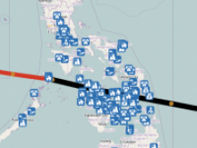
Photo credit: Overview SBTF CrisisMap Provided by Esri
In response to Typhoon Yolanda, the DHN Network has mobilized to support Palau and the Philippines. We have been contacted by United Nations Office of Coordination for Humanitarian Affairs, the Philippines Red Cross to assist in providing information management support. Highlights: On Nov 7h, the Digital Humanitarian Network received an activation request from the United Nations Office for Coordination of Humanitarian Affairs (UNOCHA) to support needs for Typhoon Yolanda. Super Typhoon Yolanda made landfall early on Nov 8 in Guiuan municipality, Eastern Samar province, Eastern Visayas region. The storm hit with 150mph winds and gusts up to 170mph. Roads have been impacted in Region V and Region VIII. There is no cell phone signal in Regions VII and VIII as well as 4 municipalities in Northern Cebu. Storm surges and flash floods have been reported in Eastern Samar and Leyte, causing significant damage to buildings and houses, according to UN OCHA. A landslide in Cebu has also been reported by the Cebu City Disaster Risk Reduction and Management Council. Strong winds and heavy rainfall have disrupted telecommunications, limiting information coming out of affected areas. UN OCHA requested information on population displacement , affected community needs and international and national humanitarian support. The deployment response is structured in three phases. Here is an overview from each solution team member.
StandbyTaskForce (SBTF): The Standby Task Force organizes digital volunteers into a flexible, trained and prepared network ready to deploy in crises; its main objective is to effectively assist crisis affected communities through co-operation with local and international responders. The SBTF is currently filtering Yolanda tweets and images by relevance to disaster responders, using the Micromappers’ Clickers software, then geolocating and categorising those tweets and images for use in the ESRI and GIScorps maps, and as raw data for the Statistics Without Borders analyses. Volunteers interested in working with the SBTF can find more information athttp://blog.standbytaskforce.com/; organisations interested in working with SBTF can contact coreteam@standbytaskforce.com directly.
Humanitarian OpenStreetMap Team (HOT): HOT performs remote mapping based on satellite imagery by tracing roads, buildings, and landuse in affected areas. Volunteers interested in supporting HOT can consult this HOT Wiki Coordination page. Contact HOT at info@hotosm.org or mailing directly to the public mailing list at HOT@openstreetmap.org If you have priority areas that your organization will be serving HOT can rapidly provide tracing of satellite imagery to create a basemap (assuming we have imagery for the area). OpenStreetMap map data is released under the Open Database License (ODBL) and you can access it via the online map, load it onto your team’s handheld GPS units, or print out paper maps for your field teams using the fieldpapers.org website. As an additional benefit, if your ground teams write information on their printed Fieldpapers map with a pen and then you scan the page or take a picture of it with a camera and send HOT the resulting image, that information will be integrated back into the central database (things like road names, locations of schools, hospitals, etc). You can also download daily updated Garmin Map Files for Garmin GPS handhelds. The maps are based on OSM data and are routeable (i.e. it will give you driving directions if you ask for it)
GISCorps: Provides volunteer GIS services to underserved communities world wide both in post disaster, humanitarian relief, and capacity building. For this deployment GISCorps is providing ad hoc Geographic Information System (GIS) mapping support to team members in the form of online maps, and acted as co-lead (with Humanity Road) in the Yolanda-Palau activities. For more information contact GISCorps at info@giscorps.org.
Esri Disaster Response Program: Supporting StandbyTaskForce and GISCorps with technical support and guidance. For more information or requests please email disaster_help@esri.com or fill out this form.
HumanityRoad: Humanity Road mission is to help the public survive, sustain and reunite in the face of disaster. Volunteers monitor at the onset of disaster to support the public and first responders with just in time information aid.Volunteers are monitoring social media, amplifying official guidance, providing the public with links to official sources of disaster response aid information and providing key information support for the Digital Humanitarian response efforts. The Humanity Road situation report provides hashtags, key social media account information, initial impacts and can be read here. For Typhoon Yolanda, Humanity Road is also leading DHN solution team Coordination.
Info4Disaster: The Info4Disasters (Info4) team deployed as part of the Solution Team, acting as Media Monitoring (MM) lead for the Standby Task Force (SBTF). The team also provides emotional support for “compassion fatigue” and assists by encouraging time management in order to avoid burnout, especially in long-term deployments such as this. This supporting team has included five (5) Info4Disasters/SBTF volunteers on a partnered and/or rotating basis in order to maximize coverage and ensure MM leadership. In addition to their role in this activation, the Info4 team has provided advocacy for families who lost contact with loved one because of Yolanda. It is essential to support efforts to locate and reunite families via social media, especially in the midst of such a disaster with communications outages and inaccessibility of locations. This support has been demonstrated by emotional support, as well as tactical support from the Info4 team.
MapAction: MapAction: Deployed two GIS volunteers to the Philippines on Thursday the 7th to work with the UNDAC/OCHA team in Manila. The team is Kirsty Ferris and Claire Byrne. MapAction is also running a support base from the UK which is the best point of contact for this deployment, - supportbase@mapaction.org. For non deployment contact please useinfo@mapaction.org.
Translators without Borders: Responded to the activation request with translation support in Tagalog. They are supporting translation of messages and keywords for monitoring.
Statistics Without Borders -- Working to describe tweet data for report purposes. At the present time, SWB have 11/7/2013 data but will be updated as more information comes in. We will also work with DHN to create a "lessons learned" and ways to improve our process after this project/task is completed. (cathy.furlong@cox.net)
Disaster Tech Lab specialises in providing internet access and communication services in disaster hit areas. This is done to reconnect affected communities but also to support other responding organisations. Disaster Tech Lab builds indoor & outdoor wifi networks, VoIP services, temporary public internet cafes etc. All services are provided for free. Currently preparing a team and equipment for deployment to the Philippines where DTL will work to reconnect affected communities. Details about DTL’s involvement as well as how to volunteer can be found here.